
You may be asking yourself, “What causes wind to blow?” The answer is simple: winds are simple the product of uneven heating of the Earth’s surface.
Table Of Content
- Introduction
- What Makes Wind Blow?
- What are the dominant winds?
- What Exactly Are Coriolis Forces?
- Wind Gusts
- Wind Shear
- How is Wind Measured?
- Using winds to forecast weather
- What are jet streams?
- Wind and climate change
- Conclusion
- FAQ
- You May Also Like
- External Links
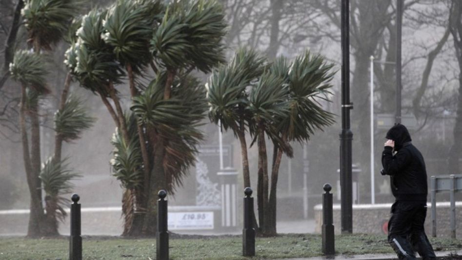
In physics, “wind” is defined as the horizontal motion of air from one location to another. As opposed to light winds, which are easier to overlook, strong winds during storms cannot be ignored.

Why does it wind up so strongly on some days and so weakly on others? So, how can we make forecasts and evaluate their impact? Here, we investigate these questions and the effects of global warming on wind energy.
What Makes Wind Blow?
Differences in air pressure, which have their origin in the sun, create wind. When solar radiation is absorbed by Earth, its heat output varies. Its varying angles of incidence result in varying degrees of heating at various locations.
Hotter regions raise atmospheric pressure by transferring heat energy to the air’s molecules, which makes them expand, heat up, and rise. The pressure drops, and a low pressure area forms as a result of the transfer.
In contrast, the air molecules inside regions of lower temperature are packed more closely together, causing them to sink as a whole and exert a strong upward push on the air above them. Centers of high pressure are what this refers to.
When heated air rises, it leaves a vacuum in its wake, which is filled by air molecules from higher pressure zones moving to lower pressure areas. The “pressure gradient force” is what drives air horizontally between high and low pressure zones, and the wind we feel is the consequence of this air rushing between the two. It is also the origin of winds aloft, such as the prevailing winds that dwell in the upper atmosphere.
What are the dominant winds?
It’s well known that there are worldwide wind belts that consistently blow the same way across the same parts of the Earth every year. For as long as there are temperature disparities, counter-current winds will continue to blow.
Wind velocity is proportional to the pressure gradient. The greater the pressure differential, the more quickly air will rush to the low pressure.
Both the location of areas of high and low pressure and the Coriolis effect work together to establish the wind’s direction.
What Exactly Are Coriolis Forces?
This is because, in the Northern Hemisphere, the air is subject to the Coriolis force, which causes it to deviate slightly to the right of its velocity path. Due to the lack of real propulsion, this is referred to as an “apparent” force. Instead, it’s an optical illusion caused by Earth’s eastward revolution.
The direction from which the wind is blowing is always used to describe its direction. Northerly winds are those that blow from the north to the south and are thus named as such.
Wind Gusts
Many obstacles, including trees, mountains, and man-made structures, may alter the wind’s direction and velocity as it blows. When airflow is reduced in this manner, the speed of the wind decreases because friction rises. When the wind finally gets around the obstruction, it speeds up in a brief, intense burst that is known as a “gust.”
Wind Shear
Wind is present at all altitudes of the atmosphere, and wind shear results from the gradual shift in wind speed and direction that occurs with altitude. These sudden shifts in the wind’s velocity or direction cause churning movements and turbulence, which may amplify and intensify severe weather, such as the thunderstorm mesocyclones that give birth to tornadoes.
Wind shear may be particularly dangerous for hurricanes and tropical cyclones because it can lop off the tops of these storms, enabling dry air to be dragged into their stomachs.
How is Wind Measured?
Wind cannot be gauged in the same way that precipitation or visibility can be because air is an unseen gas. The force it exerts on things is a better indicator of its strength.
An anemometer consists of three conical or hemispherical cups attached to a long rod and is used to measure wind speed and direction. Because the cups are open at the top, the wheel is propelled in a whirl by the wind. The anemometer’s rod is attached to a miniature generator, and its rotation is driven by the cup rotation. wheel’s The generator determines the wind speed in meters per second (m/s) or miles per hour by counting the number of revolutions (mph).
To determine which way the wind is blowing, an alternative meteorological instrument known as a wind vane is used. A vane is a kind of propeller that serves as a directional indicator. The tail’s orientation denotes the direction from which the wind is coming, and the pointer’s location shows the direction in which it is expected to blow.
A different kind of wind indicator is a windsock. These also serve as a proxy for the actual wind speed, indicating whether the air around you is completely still, lightly blowing, or roaring with violence.
Using winds to forecast weather
The winds themselves can be used for forecasting.For instance, if the wind is coming from the north, it may mean that cooler, drier air is on its way. Similarly, if the wind is blowing from the south, it may mean that warm, wet air is on its way.
Researchers in meteorology utilize wind speed and direction data to determine how quickly a weather system is traveling and, hence, how soon it will reach a certain spot. The winds of the jet stream are what guide storms throughout the United States and the rest of the world.
What are jet streams?
Jet streams are narrow bands of very fast winds that sweep across the sky from west to east. An air current is formed when hot air rises and cool air falls to replace it at the border between two air masses. Over 275 mph is the upper limit for jet wind velocity.
Air pollution isn’t the only thing that winds may transport from one region of the planet to another. The trade winds carried a cloud of Saharan dust from north Africa approximately 5,000 miles across the Atlantic Ocean in June of 2020, depositing it in the Gulf of Mexico.
Tornadoes and hurricanes may be measured in terms of their destructive potential using wind speeds, as shown by the Enhanced Fujita and Saffir-Simpson Scales.
Wind and climate change
Warming is likely to have an effect on wind patterns since winds are driven by differences in how hot the atmosphere is. The impact of climate change on large-scale circulations and local winds is, however, still poorly understood.
If the world continues to warm, the winds should gradually lessen. However, this isn’t always borne out by the results of studies. Research published in 2019 found that the average worldwide wind speed rose from 7 mph to 7.4 mph between 2010 and 2019, disproving the hypothesis that global winds have been gradually decreasing since the 1980s (a process known as “global stilling”).
Conclusion
According to these results, it’s plausible that natural climate cycles are operating inside the bigger, long-term warming trend to cause the transition from slower to faster winds every few decades. This would be the result of the natural climate cycles acting within the larger pattern. And if this turns out to be correct, it may make the wind patterns in the United States different from one place to another and from season to season.
FAQ
Name three factors that contribute to wind?
Temperature and pressure differences also play a role in driving prevailing winds, which may lead to fluctuations in local wind direction. Differential heating of land and water results in, respectively, “sea breezes” and “land breezes.”
How does wind come into existence?
It takes a little longer for the air over land to heat up throughout the day than it does over the ocean. Wind is produced when warmer air over land rises and is replaced by denser, colder air.
Where does the energy come from that generates such a brisk wind?
The rate of change in atmospheric pressure as a function of spatial distance is known as the pressure gradient. Therefore, the pressure gradient force is great when pressure varies fast over a short distance. Large pressure differences nearly always bring in strong winds.
You May Also Like
- The Great Clean Energy Acceleration: All You Need to Know
- Wind Energy: Frequently Asked Questions FAQ
- Windmill vs. Wind Turbine: What’s the Difference?
- What if Wind Farms Could Power the World?
- Wind Energy Turbines History